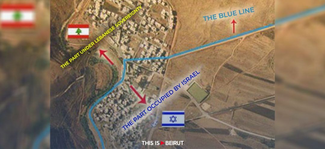
In a four-part series, This is Beirut revisits three key elements of the Lebanese-Israeli border dispute and sheds light on a fourth and often overlooked element. The first article focuses on the Ras el-Naqoura tunnel, which is owned by the Lebanese state and registered in the land registry under number 28/Naqoura, but was converted into a tourist zone by Israel since its occupation. The second article concerns the north of Ghajar, a Lebanese village occupied by Israel and whose inhabitants are Syrian.
Given the possibility of reconsidering the borders between Lebanon and Syria as part of negotiations on the implementation of UN Security Council Resolution 1701, and the broader discussion on the Golan Heights, specifically the village of Ghajar, the issue is likely to be brought to the forefront.
This intersection, where Lebanon, Syria, and Israel converge, has been at the center of a territorial dispute since the Israeli occupation of the Golan Heights in 1967. Prior to this event, the area had not been a subject of contention.
Geography and Population
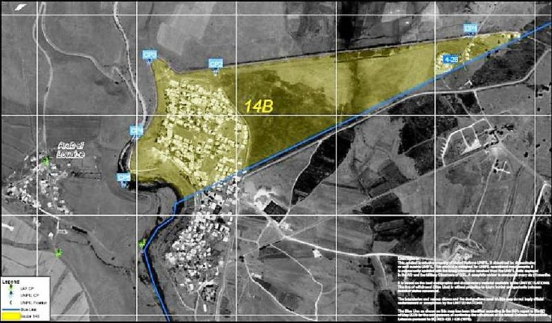
In 1516, following the battle of Marj Dabek north of Aleppo, the Ottomans emerged victorious over the Egyptian Mamluks. Fleeing northern Syria, the Alawites, who fought alongside the Mamluks, sought refuge in three villages: Ghajar (formerly known as Taranja until the 19th century), Za'oura, and Ain-Fit. While the latter two villages were completely evacuated and destroyed following the Israeli occupation in 1967, Ghajar remains inhabited. However, its northern part lies within one of the 18 disputed border points between Lebanon and Israel, marked by a technical fence that was finalized by Tel Aviv in 2007.
The fence, extending beyond the Blue Line, does not represent an officially recognized boundary but serves Israel's security interests. It runs parallel to the Blue Line and has resulted in 18 disputed points between Lebanon and Israel, with the most recent one situated in the Golan Heights, in Ghajar.
At the time, Ghajar had approximately 3,000 inhabitants (mostly Alawites) and was located at an altitude of 300 meters on the western slope of Mount Hermon, near the eastern bank of the Wazzani River, at the intersection of Lebanon, Syria, and Israel. Its original area spanned 2.5 square kilometers. During Israel's occupation of southern Lebanon between 1978 and 2000, an additional 719,000 square meters were annexed from Lebanese territory (a fact that will be elaborated on at a later time). The residents of Ghajar hold Syrian nationality (and since 1981, Israeli citizenship as well) and were initially registered in the Syrian city of Quneitra in the Golan Heights, which was destroyed by Israeli forces in 1973. Subsequently, their records were transferred to Damascus.

Ghajar Between 1932 and 1967
During the French mandate over Lebanon and Syria in 1932, the mandate authorities gave the inhabitants of Ghajar a choice: either become Lebanese citizens or keep their Syrian nationality. "Due to their sectarian affiliation, they opted for Syria. Consequently, following the land borders’ demarcation, the village remained exclusively Syrian," explains former commander of the southern Litani River sector in the Lebanese Army, General Khalil Gemayel, in an interview with This is Beirut. He further explains that "the maps held by Lebanon and the French mandate authority indicated that Ghajar was solely Syrian," contradicting Israeli claims based on British maps suggesting that it was Lebanese.
In 1967, the situation changed dramatically. This marked the onset of the dispute in the area. That year, Israel invaded and occupied the entire Golan Heights. However, Ghajar escaped occupation. "When seizing the Golan Heights, the Israelis refrained from nearing Ghajar, as, based on the British maps that were never accessible, it was regarded as a Lebanese village," Gemayel clarifies. To avoid confrontation, the Israelis relinquished control over the region. "Not being under the jurisdiction of any official state, Ghajar’s residents were unable to survive under such circumstances, facing the risk of starvation," he adds. They attempted to seek shelter in Lebanon but were denied access, as the village was officially and geographically Syrian, albeit under Israeli occupation. Therefore, they waited three weeks before calling for Israeli occupation.
Annexation of the Village of el-Mari: Lebanese Ghajar
In 1981, following the annexation of the Golan Heights by Israel, Ghajar’s residents were granted Israeli citizenship in addition to their Syrian nationality.
In 1982, during Israel's invasion of southern Lebanon, Tel Aviv opened its borders to the residents of Ghajar and allowed them to build on Lebanese territory, particularly in the village of el-Mari. "This area's significance lies in its abundant water resources, drawn from the Wazzani River. Two-thirds of Ghajar's residences were built on the Lebanese side, overlooking the source of the Wazzani River (over an area of 719,000 m2," General Gemayel explains. They subsequently set up two pumps, which are still in use today, to extract water from Lebanon.
The year 2000 marked Israel's withdrawal from southern Lebanon. The Blue Line, or the UN-drawn Israeli withdrawal line, divided the village into two parts along its main road. The southern part constituted the Syrian village of Ghajar under Israeli administration, and the northern part, which comprised the Lebanese village of el-Mari, renamed by its inhabitants as "north of Ghajar," was liberated from Israeli military control.
This delineation angered the residents of Ghajar, who protested against the splitting up of families. "Citing humanitarian concerns and in order to calm the residents' unrest, the United Nations rejected this division and opted to erect a technical fence separating the Lebanese portion of Ghajar (or el-Mari) from the rest of Lebanon, thus preventing access to this area, which remains under Israeli occupation to this day," General Gemayel recounts. He emphasizes that, "despite the Lebanese government's persistent requests to return the village’s name to its original one (el-Mari), the United Nations didn’t waver": the northern part of the region, situated within Lebanese territory, will keep on being referred to as the Syrian village of Ghajar.
Today, the withdrawal of Israeli forces from the remaining occupied Lebanese territories is stipulated in Resolution 1701. While the Israeli government has expressed on several occasions its willingness to free the village of el-Mari, Ghajar's residents rejected this measure, concerned about their fate and refusing the splitting up of their families. The only way to settle this issue is through tripartite negotiations involving the United Nations, Lebanon, and Israel.
Read more


Comments