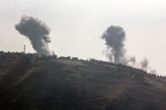
Listen to the article

Following the release of Panoramic Beirut in Arabic, French and English by Plan BEY in 2018, the second edition was showcased on May 11, 2024, at Jacaranda in Mar Mikhael. Architect and urban planner Antoine Atallah narrated, during a presentation followed by a debate in front of a large audience, the successive eras of a city in constant metamorphosis, influenced by cultural, social, economic and geopolitical fluctuations.

Panoramic Beirut traces the history of Beirut with a series of panoramic images taken from its downtown in 1870, 1910 and 1952, annotated with landmarks that constituted the city during these different periods. The depiction of a “ghost town” illustrates what was permanently lost during and after the war. A map of the downtown during the October 17, 2019, uprising captures the temporarily transformed space and concludes this publication.

Antoine Atallah shared with This is Beirut his journey as a project lead architect and urban planner at HDZ agency since 2021, after graduating in architecture from the American University of Beirut and pursuing urban studies at the École d’Architecture de Marne-la-Vallée. As Vice President of the NGO Save Beirut Heritage and active in Lebanese civil society, he undertakes missions on architectural heritage, environment, public policy and the right to the city. “The work presented here,” he says, “originated from amateur efforts through discussions on social media with a group of people passionate about photos, archives and the history of Beirut, and also through articles and books. I shared very old aerial views and tried to cross-reference photos and aerial views to locate buildings. This is not the final work that should one day exist to tell the story of Beirut, but an initial synthesis of what we discussed with the group. It was necessary to give form to this collective work and put it on paper in a pedagogical, easy-to-understand format, sharing what we know about the history of Beirut that most people are unaware of. We came across a series of panoramics showing the evolution of the city over time. From there came the idea to compile these photographic documents one after the other. I annotated the places with the help of Léa Paulikevitch on the panoramics from 1870, 1910, and 1952, and wrote a text explaining why the city changed in this way and what were the economic, political, and commercial factors.”

Antoine Atallah sequentially presented the four panoramics of the city starting with 1870, taken and edited by the studio of Felix Bonfils. The walls that surrounded the city of Beirut were demolished by the Ottomans. It featured dwellings with flat roofs topped with battlements, khans, mosques, synagogues and churches, the two Crusader fortresses, and the tower of Borj el-Kashaf, now Martyrs’ Square. The economic development benefited a merchant bourgeoisie that built large homes with three arches and tiled roofs thanks to the importation of tiles from Marseille, marble from Italy, and wrought iron from England. Various communities positioned themselves at the heart of Beirut. “Almost nothing remains today of what made Beirut in 1870,” adds the architect.

The 1910 panoramic edited by André Terzis & Sons reveals the port jetty, large docks and the destruction of the two fortresses. The red-tiled houses spread towards the Achrafieh hill and Ras Beirut. Large sections of the Arab city persisted before being razed under the French mandate. Places of worship like the Saint George Maronite Cathedral and new buildings like the Petit Serail appeared. “After 1910,” continues Antoine Atallah, “there was the first war, the fall of the Ottoman Empire, the French mandate, then the second war, and the country’s independence in 1943. These geopolitical changes induced profound urban transformations.”

The 1952 panoramic taken by Alphonse Garabédian unveils the influence of the French mandate in the city center, at Place de l’Etoile, and in the wide, straight streets. The Haussmann-style apartment buildings contrast with the Ottoman-era homes. The port expanded to the Medawar district; the Parliament, the Etoile clock and the Beirut municipality built under the mandate symbolize the emerging Lebanese republic. Following independence, Lebanon adopted modern architecture, with concrete replacing stone. Buildings, bank headquarters, offices emerged; port warehouses multiplied, expressing a market and service economy. Cinemas, cafes, restaurants, shops and grand hotels positioned themselves along the coast while some religious institutions disappeared. Martyrs’ Square became a bus station connecting all major cities and those in Syria and Palestine. “In 1952,” says Atallah, “Beirut was a palimpsest, this parchment whose parts were erased to be rewritten. The architectural diversity enriches the urban fabric. The 1975 war led to destructions in the 80s and then Solidere expropriated people to rebuild the downtown, 80% of the buildings could have been restored but only 20% remain. Martyrs’ Square has become a parking lot. The downtown is a showcase for a political and financial elite. Representing things allows us to account for them and to become aware of them.”

Antoine Atallah introduced the Al-Balad map recounting the transformation of the downtown during the October 17, 2019 revolt. The transformation of what Beirut was before 1975 was as spontaneous as it was ephemeral, “but so significant, to not forget what we are capable of imagining and building together,” he concludes.